|
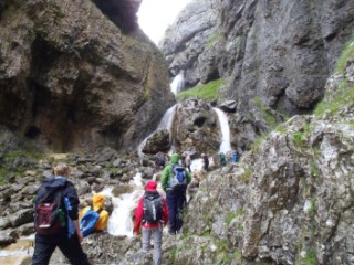
Gordale Scar
| Height: |
800 feet climbing to 1,070 feet |
 |
| Area: |
Malhamdale |
| Grid Ref: |
SD 915 640 |
| Map: |
OS Explorer OL2 Yorkshire Dales S & W Areas |
| Type: |
Limestone Gorge |
|
DATE |
WALK |
DISTANCE |
ASCENT |
TIME TAKEN |
|
Sunday, 1st July 2012 |
River Aire, Calton,
Weets Top, Gordale Scar, Street Gate,
Gate Close, Malham Tarn, Watlowes, Malham Cove, Malham, River Aire |
16.3 mls |
2,170 ft |
6.75 hrs |
|
Sunday, 22nd August 2010 |
Skirethorns, Mastiles Lane, Street Gate,
Gordale Scar, Weets Top, Boss Moor |
15.5 mls |
2,200 ft |
6.5 hrs |
|
Sunday, 25th March
2007 |
Airton, Malham, Malham Cove, Watlowes, Street
Gate, Gordale Scar, Weets Top, Airton |
12 miles |
2,500 feet |
- |
Return to Other
Summits List
|